

Quick answer
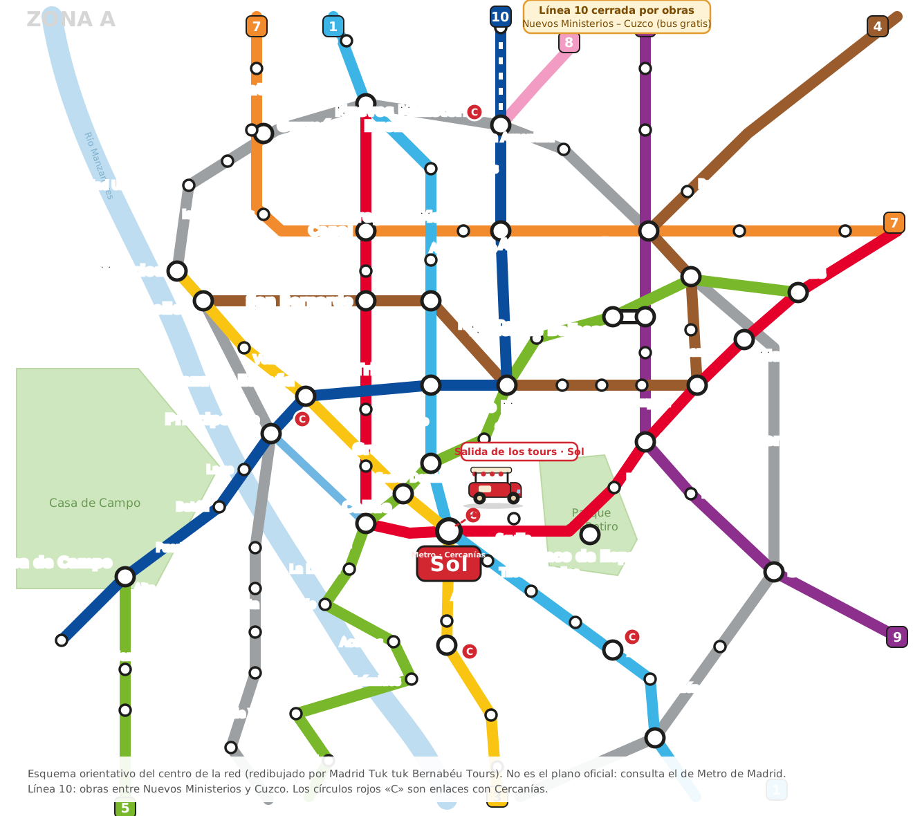
You can download here, as a PDF, a diagram of the centre of the Madrid Metro network with lines 1 to 10, the Ramal, the main stations and Cercanías links. It is our own redrawing, not the official map: the full official map is available as a PDF from the Madrid Regional Transport Consortium, linked below.
Download the Madrid Metro map as a PDF
Download the city-centre diagram (PDF) · Download as SVG
It is a diagram of the centre of the network, redrawn by Madrid Tuk tuk Bernabéu Tours for travellers. It marks Sol station, where our tours start. It is not Metro de Madrid's official map and does not include the whole network.
The centre map, station by station
Central lines and key stations
| Line | Central stations (in order) | Links |
|---|---|---|
| Line 1 | Cuatro Caminos, Ríos Rosas, Iglesia, Bilbao, Tribunal, Gran Vía, Sol, Tirso de Molina, Antón Martín, Estación del Arte, Atocha, Menéndez Pelayo, Pacífico | Sol (2, 3), Atocha (Cercanías) |
| Line 2 | Ventas, Manuel Becerra, Goya, Príncipe de Vergara, Retiro, Banco de España, Sevilla, Sol, Ópera, Santo Domingo, Noviciado, San Bernardo, Quevedo, Canal, Cuatro Caminos | Sol, Ópera, Cuatro Caminos |
| Line 3 | Moncloa, Argüelles, Ventura Rodríguez, Plaza de España, Callao, Sol, Lavapiés, Embajadores, Palos de la Frontera, Delicias | Sol, Callao |
| Line 5 | Casa de Campo, Campamento, Empalme … Marqués de Vadillo, Pirámides, Acacias, Puerta de Toledo, La Latina, Ópera, Callao, Gran Vía, Chueca, Alonso Martínez, Rubén Darío, Núñez de Balboa, Diego de León, Ventas | Callao, Gran Vía, Ópera |
| Line 10 | Casa de Campo, Batán, Lago, Príncipe Pío, Plaza de España, Tribunal, Alonso Martínez, Gregorio Marañón, Nuevos Ministerios, Santiago Bernabéu, Cuzco, Plaza de Castilla, Chamartín | Príncipe Pío, Nuevos Ministerios |
| Line 8 | Nuevos Ministerios, Colombia, Pinar del Rey, Mar de Cristal, Feria de Madrid, Aeropuerto T1-T2-T3, Barajas, Aeropuerto T4 | Nuevos Ministerios |
| Ramal (R) | Ópera, Príncipe Pío | Ópera, Príncipe Pío |
Lines 4, 6, 7 and 9 are also on the map: line 4 links Argüelles, Bilbao, Alonso Martínez, Goya and Avenida de América; line 6 is a circle; line 7 runs through Canal, Gregorio Marañón and Avenida de América; and line 9 links Plaza de Castilla, Avenida de América, Príncipe de Vergara and Sainz de Baranda.
How we checked the map
We checked the station order and links of every line on the map against the public station lists of each Metro de Madrid line (consulted on 19 October 2026). Things worth knowing:
- In the current line 1 listings, the station next to the train station appears as Atocha and the previous stop as Estación del Arte; older maps show «Atocha Renfe».
- The line 1 Chamberí station is closed and is not on the map.
- Line 10 is closed for works between Nuevos Ministerios and Cuzco, including Santiago Bernabéu station, with a free replacement bus.
Because it is a diagram, it does not respect real distances between stations and there may be minor differences from the official map.
The full official map, as a PDF
For travel, always use the official map. The Madrid Regional Transport Consortium publishes these PDFs:
- Metro and Metro Ligero network map (PDF, Regional Transport Consortium)
- Tourist transport map (PDF, Regional Transport Consortium)
Ticket prices and the Multi card are in Madrid Metro for tourists.
From the map to the street
With the map on your phone, the centre is easy by Metro, but some stations have lots of stairs. If you prefer to see the key sights without going up and down, a private 1-hour tuk tuk leaves from Puerta del Sol and takes you through them with a driver-guide. If you go at night, see how to get around Madrid at night.
Frequently asked questions
Where can I download the Madrid Metro map as a PDF?
You can download a city-centre diagram as a PDF here, made by us. The full official map is available as a PDF from the Madrid Regional Transport Consortium, linked on this page.
Is this the official Madrid Metro map?
No: it is an indicative diagram of the centre redrawn by us. For travel, use the official map.
Which Metro lines run through central Madrid?
Lines 1, 2, 3, 5 and 10 cross the centre, along with 4, 6, 7, 9, the Ópera–Príncipe Pío branch and line 8, which leaves Nuevos Ministerios for the airport.
Is line 10 open to the Bernabéu?
No: it is closed for works between Nuevos Ministerios and Cuzco, including Santiago Bernabéu station, and a free replacement bus runs.
Sources
- Madrid Regional Transport Consortium: Metro network map (PDF)
- Madrid Regional Transport Consortium: tourist map (PDF)
- Line 1 of the Madrid Metro (station list)
- Line 10 of the Madrid Metro (station list)
Facts and prices checked on 19 October 2026. They can change: confirm them with the official source before you travel.